
There is a moment on the Pangarchulla Peak Trek where you stop thinking about your legs. About the 4 am start. About the snow slope you just spent an hour crawling up in crampons. All of that just goes. Because you are standing at 4,700 metres above sea level with Nanda Devi, Kamet, Dronagiri, Hathi Parbat and Mana Parbat arranged around you in a full 360-degree sweep, and your brain, frankly, cannot process the legs anymore.

That moment is what the Pangarchulla Peak Summit is about. But — and this is important — it does not give that moment away cheaply. You have to earn it. Which is exactly why it is so good.
MOST PEOPLE COME TO JOSHIMATH FOR AULI’S SKI SLOPES OR THE VALLEY OF FLOWERS. PANGARCHULLA IS FOR THE ONES WHO WANT TO KNOW WHAT IS ON THE OTHER SIDE OF THE OBVIOUS. AND THE ANSWER, IT TURNS OUT, IS RATHER EXTRAORDINARY.
Pangarchulla Summit trek is classified as moderate-to-difficult. For a first-timer, that means it is absolutely doable — but not if you have spent the last six months on a sofa. You need reasonable fitness, a good guide, and the willingness to start walking at 4 am on summit day in the dark with crampons strapped to your boots. If that sounds exciting rather than alarming, you are the right person for this trek.
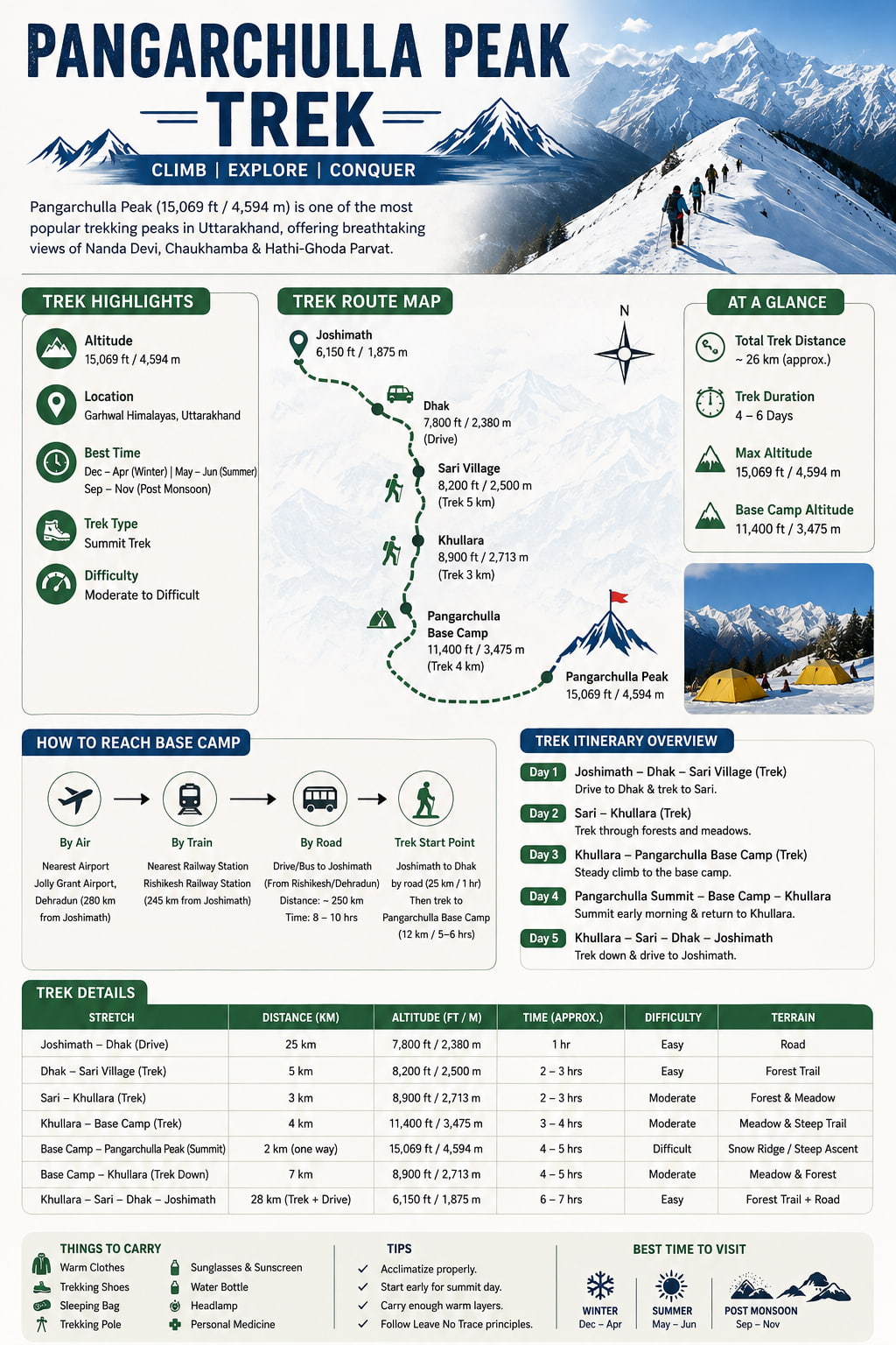
Pangarchulla Peak Trek — At a Glance
| Difficulty | Moderate to Difficult |
| Best season | April to June · September to October |
| Duration | 5–6 days from Joshimath |
| Max altitude | 4,700 metres (Pangarchulla summit) |
| Trek distance | Approximately 54 km total |
| Starting point | Dhak village, 12 km from Joshimath |
| Permits | None required |
| Trek type | Out and back |
| Guide | Required — non-negotiable on this one |
A Small Geography Lesson First
Pangarchulla sits in the Garhwal Himalayas of Uttarakhand, in the Chamoli district — the same district that gives you Nanda Devi, Valley of Flowers, Badrinath, and the Kuari Pass. It shares its approach trail with the Kuari Pass trek for the first three days, diverging only at the base camp before summit day. Which means if you have done the Kuari Pass and thought — I want more — Pangarchulla is the logical next conversation.
The peak itself sits at the junction of the Garhwal and Kumaon Himalayas. The name Pangarchulla comes from the local Garhwali language — pangar meaning a type of oak tree, chulla meaning hearth or fireplace. So essentially: the fireplace of the oaks. Which is a rather lovely way to describe a mountain.
Things to Expect on the Pangarchulla Trek…
The forest. The approach trail from Dhak goes through some of the finest oak and rhododendron forest in Uttarakhand. In April it is all red and pink bloom. In October it turns gold and copper. In either case, the forest is doing something interesting and you should pay it the attention it deserves. Most trekkers are so focused on what is ahead that they miss what is around them on days one and two. Do not be those trekkers.
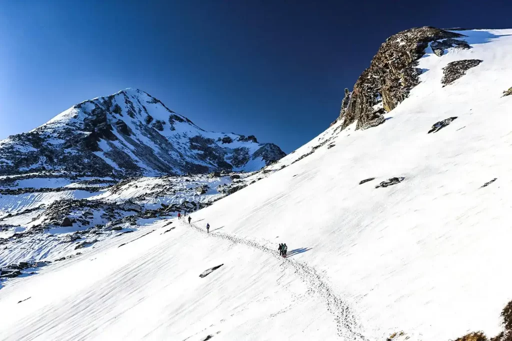
The meadows. Gorson Bugyal opens up around day two like a slow reveal — you are in forest and then suddenly you are not. You are in a wide alpine meadow with big Himalayan peaks appearing on the horizon. Think of it like the difference between reading about India and actually arriving at the airport. No photograph quite prepares you for the scale.
Kuari Pass on day three. You cross the Kuari Pass at 3,640 metres before descending to Pangarchulla base camp. Most people have heard of the Kuari Pass. Most people think of it as the destination. On the Pangarchulla trek, it is just the middle of the story. The views from the pass — Nanda Devi front and centre, with Kamet and Dronagiri on either side — are worth the whole trip on their own. And you are not even at the summit yet.
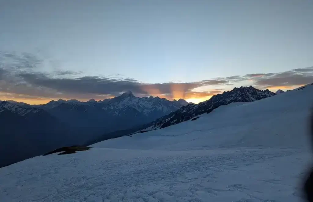
The 4 am start. Summit day begins in the dark. This is not dramatic — it is practical. You need to reach the summit and return before afternoon clouds roll in and visibility drops. Your guide will wake you at 3:30 am. You will eat something warm, strap on crampons, and start climbing with a headtorch. The sky goes from black to deep blue to pink to gold as you climb. By the time you reach the top, the sun will be fully up and the Himalayas will be lit like something from a film that doesn’t seem real.
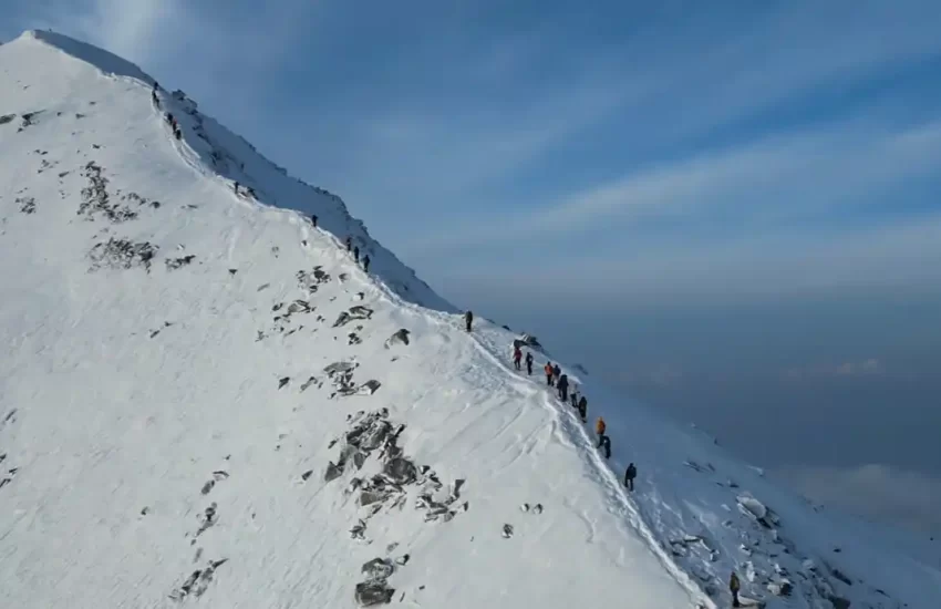
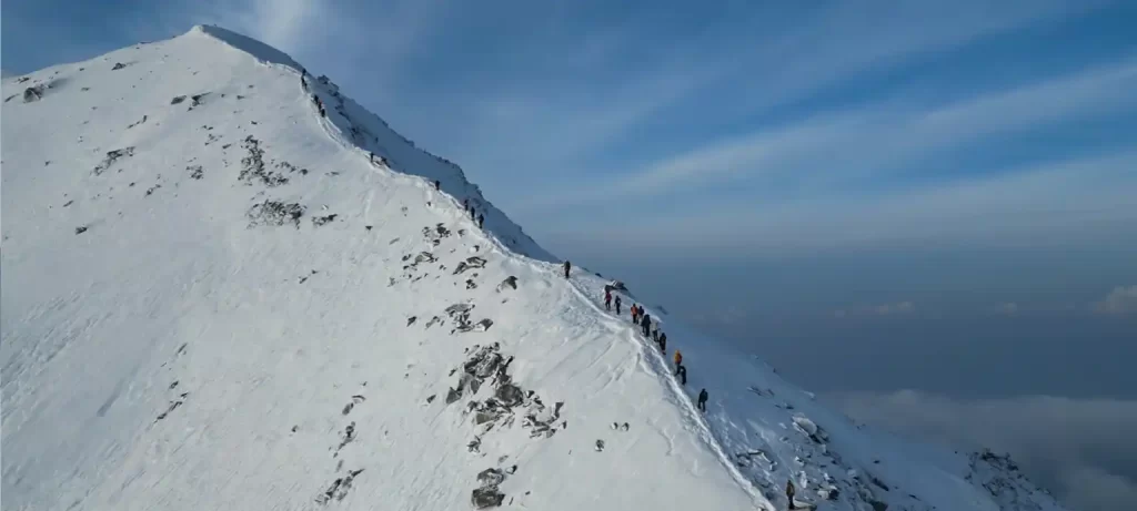
The snow slope. The final section to the Pangarchulla summit involves a steep snow slope — this is the section that separates it from the Kuari Pass in terms of difficulty. Crampons are essential in season. So is a guide who knows how to read the snow conditions. In good conditions with good preparation, it is tough but manageable. In bad conditions, your guide will tell you to turn back. Listen to them.
The summit. At 4,700 metres, the Pangarchulla summit offers one of the finest panoramic views in the accessible Garhwal Himalayas. Nanda Devi at 7,816 metres dominates the skyline. Kamet, Dronagiri, Hathi Parbat, Mana Parbat — all visible, all enormous. On a clear April or October morning, the visibility extends to peaks that are 80 kilometres away. You will stand there longer than you planned. That is correct behaviour.
Day-by-Day Itinerary
This assumes you arrive in Joshimath the day before the trek starts. Do not skip this. One night at 6,150 feet before you start climbing is how you avoid altitude sickness on day one.
| Day | Route | Distance | What Happens |
|---|---|---|---|
| Day 0 | Joshimath | — | Arrive, rest, eat well. Guide briefing in the evening. This night is not optional — acclimatization starts here. |
| Day 1 | Dhak → Gulling | 9 km | Drive to Dhak (12 km from Joshimath). Trek begins through oak and rhododendron forest. Steady climb. Overnight camp at Gulling, around 3,100 m. |
| Day 2 | Gulling → Tali | 6 km | Shorter day, higher gain. The meadows start opening. Tali lake at 3,354 m is your camp. Cold, clear, beautiful. The peaks start showing themselves. |
| Day 3 | Tali → Kuari Pass → Pangarchulla Base | 8 km | Cross Kuari Pass (3,640 m). Views of Nanda Devi, Kamet, Dronagiri. Continue to Pangarchulla base camp. This is where you sleep before the summit. |
| Day 4 | Summit day — Pangarchulla Peak | 5 km up, 5 km back | Pre-dawn start. Steep snow slope. Crampons on. The summit at 4,700 m. 360-degree views. Return to base camp, then descend to Tali or Gulling. |
| Day 5 | Camp → Dhak → Joshimath | 9 km | Final descent through the forest. Drive back to Joshimath. Hot meal. Long sleep. It is over. Except it never really is. |
Things Not to Do on the Pangarchulla Trek…
Underestimate the summit slope. The Pangarchulla Trek Uttarakhand is not a steep hill. It is a snow slope that requires crampons, a steady head, and a guide who knows the route. People who have done the Kuari Pass and assume Pangarchulla is just a bit more of the same are in for a surprise. It is more. Specifically, it is the kind of more that requires equipment, preparation, and willingness to turn back if conditions say so. The mountain does not negotiate.
Skip the fitness work. This is the honest bit. Pangarchulla at 4,700 metres with a steep summit push is not the trek to attempt if your usual exercise is a walk to the car. Give yourself at least six weeks of regular hiking before you arrive — ideally including some long climbs with elevation gain. Your body will tell you on summit day exactly how much or how little work you put in beforehand. The Himalayas are not a gym. They do not accept beginners who have not done the homework.
Go without a certified guide. This is non-negotiable on Pangarchulla. The route to the summit involves route-finding on snow, reading conditions, knowing when to push and when to turn back. A guide who knows this mountain has made that call before — sometimes in your favour, sometimes not. Either way, their judgment is what keeps this a good story rather than a bad one. Do not go without one.
Ignore altitude symptoms. Headache, nausea, dizziness, loss of appetite at altitude — these are your body sending a message. The message is: slow down. If symptoms appear above 3,500 metres, tell your guide immediately. Do not hide them. Do not push through them. Altitude sickness above 4,000 metres is not something you walk off. Descend, rest, reassess. The summit will be there next season.
Arrive without the right kit. Crampons, micro-spikes or similar traction devices are not optional on the summit slope from approximately March through May, and again in October. Your trek operator will advise on exact conditions for your departure date. Do not assume it will be fine. Do not buy cheap crampons in Joshimath the day before. Either rent good ones from a reputable operator or bring your own. Your feet on a steep snow slope at 4,500 metres is not the place for false economy.
Specifically for First-Timers…
Pangarchulla is listed as moderate-to-difficult, which leads some first-timers to assume it is out of reach. It is not. The Searching Souls, one of the regional trek operators who run this route regularly, specifically market it to motivated first-timers with good fitness. The difference between a first-timer who completes Pangarchulla and one who doesn’t is not experience — it is preparation.
If this is your first Himalayan trek, here is the honest version of what to expect. The first two days feel manageable — the forest is beautiful, the altitude is building gradually, the campsites are well-established. Day three — crossing Kuari Pass and continuing to base camp — is the hardest day before summit day. Your legs will know about it. Day four, summit day, is where it all comes together: the 4 am start, the snow slope, the summit, the view, the descent. It is a very full day. And the day after, the descent back to Joshimath, your knees will have opinions.
The trail gradually opens into expansive alpine meadows, offering uninterrupted views of some of the highest peaks in India. As you move higher, the air gets thinner, the silence deeper, and the landscape more dramatic. Every step feels like a transition from the ordinary to something far more raw and powerful.
Best Time to Do the Pangarchulla Trek
April to June. The rhododendron is in bloom on the lower slopes, the snow on the summit slope is firm and good for crampons, and the skies are mostly clear. This is the most popular season. The higher you go, the more snow you will find — which is part of the experience.
September to October. Post-monsoon clarity means visibility can be extraordinary — the kind where you can see individual ridgelines on peaks 80 kilometres away. The forest is turning golden. Temperatures are dropping. October especially gives you crisp, cold, perfectly clear summit conditions.
July to August. Do not. The monsoon makes the trail unstable, visibility is poor, and the summit slope becomes dangerous. Save it for another season.
November to March. The pass and summit are under deep snow. Only for experienced winter trekkers with the right equipment and an operator who specialises in winter routes. Not a first-timer season.
Where to Stay — Before and After the Trek
Every Pangarchulla itinerary starts and ends in Joshimath. The night before is when the real preparation happens — guide briefing, kit check, a proper hot meal, sleep at altitude. The night after, when you come back from Dhak having just stood on a 4,700 metre summit, is when Joshimath earns its place on the itinerary all over again. Hot shower. Hot food. Horizontal.
Blackberry Cottages & Resort at Auli Laga, Joshimath offers Pangarchulla Trek + Stay packages with accommodation, meals, certified guide briefing, packed breakfast for summit day, and full trek logistics from Joshimath. We are 12 kilometres from Dhak village — your starting point — and have hosted trekkers on this route across multiple seasons.
JOSHIMATH IS WHERE THE PANGARCHULLA TREK BEGINS AND WHERE IT ENDS. THE BASE YOU CHOOSE MATTERS AS MUCH AS THE BOOTS YOU WEAR. BOTH SHOULD BE SORTED BEFORE YOU ARRIVE.
Complete Trek information in short
Check fixed departure dates and package details at blackberrycottagesauli.com or reach us on WhatsApp to plan your trip.